Property Record
Camp Creek Pkwy, East Point, GA 30344

NEARBY LISTINGS FOR SALE OR LEASE
Property Detail
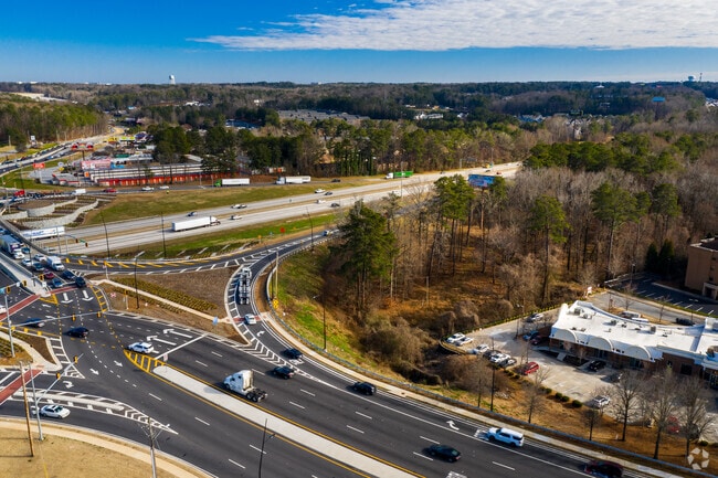
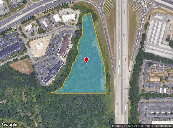
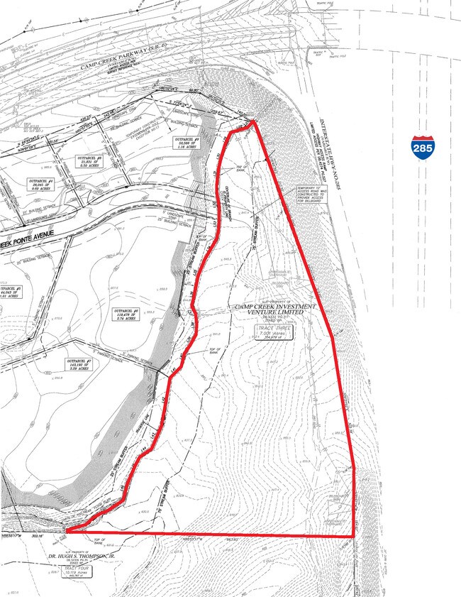
Camp Creek Pkwy
Atlanta-Sandy Springs-Roswell, GA
Camp Crk Pointe
14-0256-LL-011-0
Fulton
Commercialacreage
Georgia
X
9
13121C0363F
6.90 AC
2024
North Clayton/Airport
2025
Atlanta
011310
DEMOGRAPHICS near Camp Creek Pkwy
1 Mile
3 Mile
5 Mile
2024 Total Population
11,694
56,695
147,090
2029 Population
12,081
58,696
152,027
Pop Growth 2024-2029
+ 3.31%
+ 3.53%
+ 3.36%
Average Age
34
38
38
2024 Total Households
5,243
23,478
59,744
HH Growth 2024-2029
+ 3.09%
+ 3.44%
+ 3.36%
Median Household Inc
$48,153
$53,714
$54,520
Avg Household Size
2.20
2.30
2.40
2024 Avg HH Vehicles
1.00
1.00
1.00
Median Home Value
$221,768
$238,837
$230,300
Median Year Built
1989
1978
1978
Nearby Places
Map Layers
Map Styles
 Street
 Aerial
- Restaurants
- Banks
- Shops
- Fitness
- Groceries
PUBLIC TRANSPORTATION
AIRPORT
Hartsfield - Jackson Atlanta International
DRIVE
WALK
Distance
Hartsfield - Jackson Atlanta International
16 min
9.8 mi
Freight Ports
Georgia Ports - Savannah
DRIVE
WALK
Distance
Georgia Ports - Savannah
278 min
247.0 mi
SALE & LEASE HISTORY
LISTING DATE
SALE/LEASE

Sep 24, 2016
For Sale
Mar 30, 2017
For Sale
Jan 12, 2021
For Sale
Nearby Properties
Address
Land Use
TOTAL SIZE
Lot Size
Zoning
Address
Land Use
TOTAL SIZE
Lot Size
Zoning
2,666 SF
46.88 AC
BP
Address
Land Use
TOTAL SIZE
Lot Size
Zoning
2,666 SF
0.43 AC
Address
Land Use
TOTAL SIZE
Lot Size
Zoning
2,666 SF
0.43 AC
Address
Land Use
TOTAL SIZE
Lot Size
Zoning
2,666 SF
0.43 AC
Address
Land Use
TOTAL SIZE
Lot Size
Zoning
2,666 SF
0.43 AC
Address
Land Use
TOTAL SIZE
Lot Size
Zoning
2,666 SF
0.43 AC
Address
Land Use
TOTAL SIZE
Lot Size
Zoning
2,666 SF
0.43 AC
Address
Land Use
TOTAL SIZE
Lot Size
Zoning
2,666 SF
0.43 AC
Address
Land Use
TOTAL SIZE
Lot Size
Zoning
2,666 SF
0.43 AC
Address
Land Use
TOTAL SIZE
Lot Size
Zoning
2,666 SF
0.43 AC
Address
Land Use
TOTAL SIZE
Lot Size
Zoning
2,666 SF
0.43 AC
Address
Land Use
TOTAL SIZE
Lot Size
Zoning
293,211 SF
23.51 AC
C
Address
Land Use
TOTAL SIZE
Lot Size
Zoning
270,503 SF
4.56 AC
C
Address
Land Use
TOTAL SIZE
Lot Size
Zoning
196,294 SF
0.49 AC
R1
Address
Land Use
TOTAL SIZE
Lot Size
Zoning
356,458 SF
18.72 AC
PDMU
Address
Land Use
TOTAL SIZE
Lot Size
Zoning
6,402,340 SF
22.62 AC
MF
Address
Land Use
TOTAL SIZE
Lot Size
Zoning
4,455,803 SF
16.39 AC
C2
Address
Land Use
TOTAL SIZE
Lot Size
Zoning
6,069,632 SF
26.42 AC
R4
Address
Land Use
TOTAL SIZE
Lot Size
Zoning
1,231,833 SF
15.51 AC
C2
Address
Land Use
TOTAL SIZE
Lot Size
Zoning
330,838 SF
13.71 AC
PDMU
Address
Land Use
TOTAL SIZE
Lot Size
Zoning
5,459 SF
12.97 AC
C1
Address
Land Use
TOTAL SIZE
Lot Size
Zoning
282,610 SF
11.20 AC
C1
Address
Land Use
TOTAL SIZE
Lot Size
Zoning
235,301 SF
27.20 AC
C2MC
Address
Land Use
TOTAL SIZE
Lot Size
Zoning
364,391 SF
25.33 AC
R4
Address
Land Use
TOTAL SIZE
Lot Size
Zoning
137,475 SF
2 AC
C
Address
Land Use
TOTAL SIZE
Lot Size
Zoning
920,396 SF
62.40 AC
R3
Address
Land Use
TOTAL SIZE
Lot Size
Zoning
663,520 SF
62.96 AC
C1
Address
Land Use
TOTAL SIZE
Lot Size
Zoning
213,314 SF
16.48 AC
C2C
Address
Land Use
TOTAL SIZE
Lot Size
Zoning
71.46 AC
C
Address
Land Use
TOTAL SIZE
Lot Size
Zoning
2,057,484 SF
14.78 AC
R4
The World's #1 Commercial Real Estate Marketplace
Connect with us
© 2025 CoStar Group
The information above has been obtained from sources believed reliable. While we do not doubt its accuracy we have not verified it and make no guarantee, warranty or representation about it. It is your responsibility to independently confirm its accuracy and completeness. Any projections, opinions, assumptions, or estimates used are for example only and do not represent the current or future performance of the property. The value of this transaction to you depends on tax and other factors which should be evaluated by your tax, financial, and legal advisors. You and your advisors should conduct a careful, independent investigation of the property to determine to your satisfaction the suitability of the property for your needs.